Location: Great Falls, MD
Type of buffer: Urban, Private Residential, Virginia Conservation Assistance Program (VCAP)
Partners Involved: Lee Family, Deco Footprint team, Northern Virginia Soil and Water Conservation District (NVSWCD) team, F&F Landscaping team
Submitted by: Adele Kuo
Project Budget: Approximately 975 square feet new riparian buffer
Planning, Design, Getting Approvals, Site Prep & Plants: $2,800
Equipment & Materials: $2,500
Installation/Labor: $1600 per day $3,200
Total Project Budget: $8,500
VCAP Cost-Share Rebate: $3,500
Most people in Northern Virginia live within half a mile of a small local stream. If you’re lucky, you may enjoy living with a stream on your property. TWO streams intersect on the Lee Family property at 825 Walker Road making this four-acre property special for many reasons.
First, Mrs. Cathryn Lee’s father was a renowned architect and custom designed the modern style home with lots of large windows to face the streams. In 1995, her brother built the custom home from their father’s plan to enjoy views of the two streams. Back then the small streams on their property were not protected by the Resource Protection Area (RPA) so they were allowed to build roughly 45’ from the stream. But in 2003, the RPA was extended and now approximately 3.5 acre (86%) of their 4.0 acre property is in the RPA. A few years back, her son in law tried to address the streambank erosion by adding timber retaining walls.
Second, location, location, location! Both streams on the Lee property originate less than a mile away from the charming town of Great Falls, VA. The stream flowing mostly southeast from Great Falls emerges from the Village Green Day School while the other stream flowing mostly south from Great Falls starts from the Great Falls Grange Historic Property managed by the Fairfax County Park Authority before both small streams merge on the Lee property about 45 feet from the family’s deck and patio. Both streams feed into Captain Hickory Run in the Difficult Run Watershed, the largest watershed in Fairfax County, which drains directly into the Potomac River in the southeast corner of Great Falls National Park less than a 10-minute drive from the Lee Property, Thus, when it rains all the impervious surface runoff from suburban Great Falls flows downstream through the Lee Property where they merge and continues to flow downstream emptying directly into the Potomac River, the source of drinking water for Fairfax County.
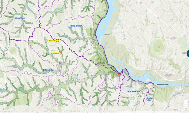
Location of the Lee Property in Difficult Run Watershed
So even though their idyllic property feels rural, suburban amenities are less than a mile away in Great Falls, less than six miles northeast of Reston Town Center and less than seven miles northeast of Tysons Corner, the 12th-largest business district in the US! As the area upstream continues to develop and add more impervious surfaces, when it rains the Lee family sadly watches the sudden and fast increased runoff flow through their yard like the Potomac River nearby in Great Falls National Park builds up speed and force as it falls over rocks and flows through the narrow Mather Gorge; after only 30 years their once beautiful streams carved out deep, wide, ugly gashes in the earth with steep, cut banks.
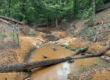
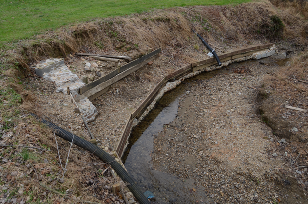
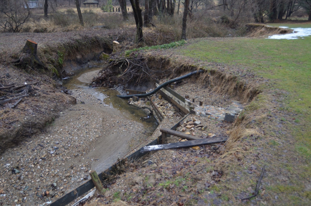
Since 1995, the Lee Family watched the area develop and their streambanks change dramatically. A surge of development upstream in the town of Great Falls, including new homes, commercial buildings, parking lots, and roads, meant more stormwater runoff and more streambank erosion on the property. In addition, two farm ponds upstream empty runoff into their little stream. When we first walked their property together in fall 2020, Cathryn Lee showed us exposed pipes and wires, and even a downed telephone pole as a result of the severe erosion of their stream banks over the last 30 years. Due to the severe undercut streambanks, several trees fell so were cut down and removed. Her brother in law tried to remedy the streambank erosion by building timber retaining walls.
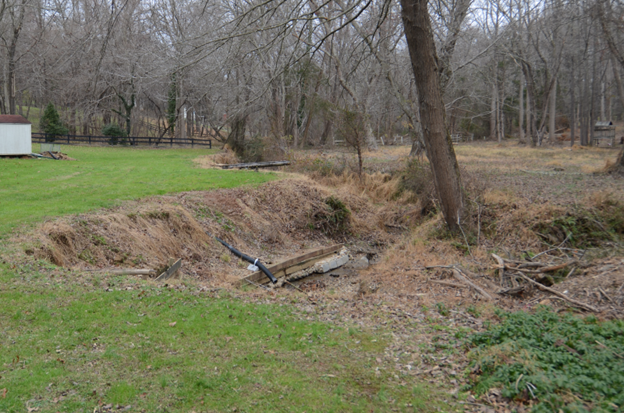
Stream bank erosion and degradation from increased development upstream
Planning, Design, Applications
To protect their family treasure, the Lee Family hired Deco Footprint in Feb. 2021 to plan, design, and submit a potential Virginia Conservation Assistance Program (VCAP) Conservation Landscaping Project Application and Resource Protection Area (RPA) Waiver to add a Conservation Landscaping (aka Riparian Buffer) planting within the RPA on their property.
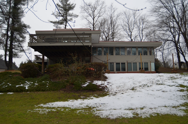
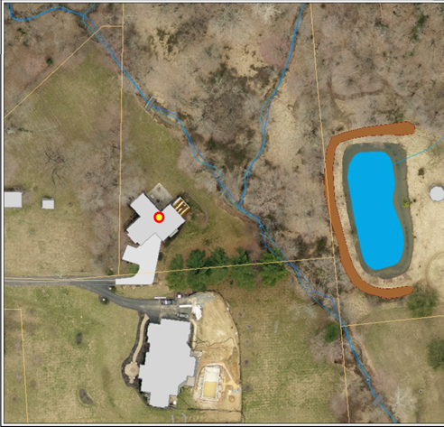
Because the family enjoys the views of the natural floodplain from the bank of windows of their home, as well as from their exterior deck, and patio, they requested that the Conservation Landscaping Project be located within easy view of their house windows, deck, and patio.
The goal: restore as much of the stream buffer along the creek bank as possible to preserve a small but invaluable piece of the Difficult Run Watershed which flows directly to the Potomac River and eventually reaches the Chesapeake Bay Watershed.
The challenge: 1-about 86% of the property is in an environmentally sensitive area labelled Resource Protection Area (RPA), and therefore, requires a 100-foot buffer zone to protect the two streams. 2-encroachment from invasive species (such as Glechoma hederacea, Creeping Charlie, and Microstregium vimineum, Japanese Stiltgrass) also posed a serious threat and should be addressed while minimizing streambank disruption.
Originally, we were excited and thinking of a buffer along the stream running parallel to the back of the house from property line to property line.
After reviewing rough budgets, site accessibility, and VCAP program requirements with Dr. Al and Mrs. Cathryn Lee, we agreed to pull back and focus on the area of the stream directly downhill from the house and patio where the erosion appears the worst and where they wanted to enjoy the views of the new buffer planting. So we submitted the following concept plan below as part of the VCAP project application.
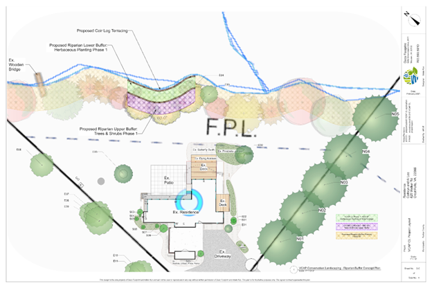
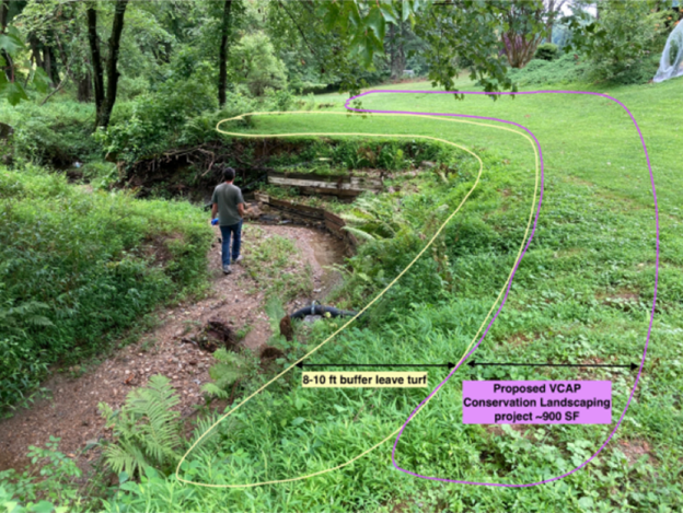
The Technical Review Committee was generally supportive of the VCAP project application except for their concern of the active and unpredictable nature of the stream as evidenced by photos of the severely degraded character of the channel and banks. The committee recommended to create an 8-10’ buffer strip where the existing turf is not disturbed due to the fragile nature of the bank. Thus the proposed conservation landscaping bed planting should be located no closer than 8-10’ to the stream edge, see below. This 8-10’ turf buffer strip is necessary to assure the survival of the new plantings over the long term since VCAP requires a 10-year commitment to maintain the proposed practice.
Once we adjusted the plans to move the buffer planting ~10 ft off the banks, the project was approved for a VCAP cost-share rebate. Next, the Fairfax County waiver to remove turf grass in the RPA and replace with a riparian buffer planting was approved.

Project Design | Build
The Deco Footprint planting plan takes into account the Lee Family’s desire to have an aesthetically pleasing view of the floodplain and provide interesting color, texture, and height year round, resulting in a riparian buffer that has served to be both beautiful and ecologically functional.
The design evolved into 3 vegetated ribbons of 100% Virginia native plants running along the stream bank but set back 10’ from the stream edge:.
- A diversity of Virginia native shrubs in the first purple ribbon running along the 10’ turf buffer strip not only provide more visual interest but creates a healthier and more resilient ecosystem by providing varied food and shelter for wildlife, and supporting a wider range of insect life. Riparian shrubs such as Cornus sericea and C. racemosa, Lindera benzoin, Viburnum dentatum, and Hamamelis virginiana offer diverse root depths, fruit, nectar, and foliage that contribute to more effective erosion control and provide a more complete habitat compared to a monoculture.
- Next, three Nyssa sylvatica (Blackgum) underplanted with Panicum virgatum anchor the middle gold ribbon. Both plants were selected for their adaptability to moist or poorly drained soil and tolerance for periodic drought. Both well-known for strong root systems to help stabilize steep slopes, stream banks, and reduce erosion. Both plants also offer significant benefits for wildlife while providing brilliant fall color.
- Lastly, the bright pink ribbon furthest uphill will be a stylized upland meadow edge planned with a matrix of Panicum virgatum and long-blooming summer flowering forbs weaving its way through the matrix. Clusters of Ilex glabra punctuate the meadow plus a border of Carex amphibola provide winter greenery when most native plants are dormant.
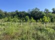
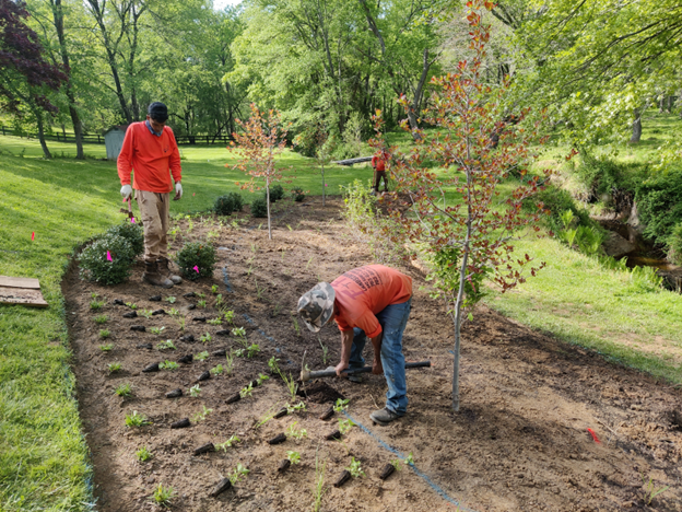
May 2022: Installing the Project
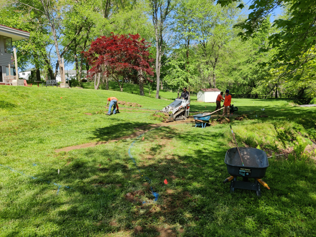
Dingo removes the turf more efficiently than manually.
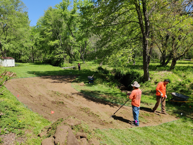
Remaining turf manually cut by sod cutter, rolled and removed.
Panicum virgatum is the matrix plant in the upper “hot pink” ribbon. Drifts of 3 species of long-blooming summer perennials distributed through the matrix.
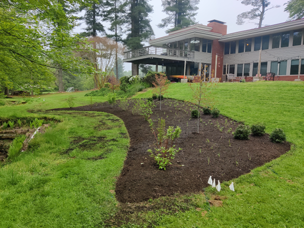
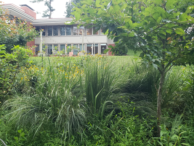
An aesthetically beautiful, 100% Virginia native planting complements the peaceful view of their meandering stream and natural floodplain, while protecting a family treasure, the water quality of the stream and larger watershed downstream.
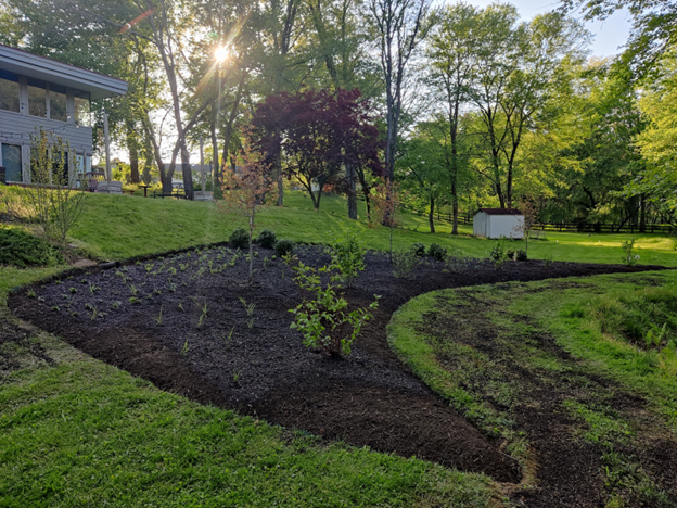
May 2022: View of the Completed Project Planting the Next Day
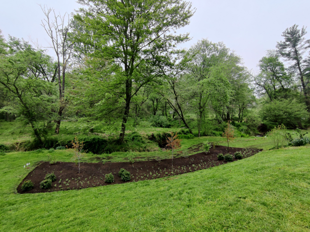
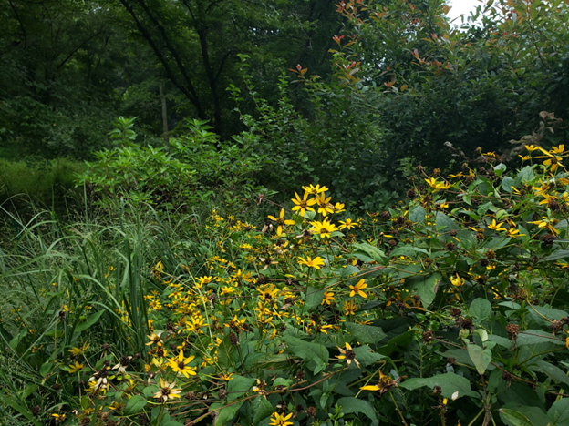
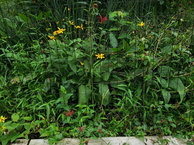
August 2022: 3-month post visit:
Panicum virgatum and the other herbaceous in the upper “ribbons” of the planting show nice growth within 3 months of the planting, some deer damage visible, an Inkberry appears dead.
The All In The Family: Help Protect Our Treasured Streams Only 45’ From Our House Deck project in Great Falls, VA, demonstrates how a family’s love for their land evolved into a model for urban watershed stewardship. Located on the Lee family’s four-acre property—where two small streams converge just 45 feet from their deck—this project addresses severe streambank erosion caused by decades of upstream suburban development. Partnering with Deco Footprint, the Northern Virginia Soil and Water Conservation District, and F&F Landscaping, the Lees designed and installed a 975-square-foot native riparian buffer through the Virginia Conservation Assistance Program (VCAP). Completed in May 2022, the project features layered “ribbons” of 100% Virginia native trees, shrubs, and meadow plants, set back 10 feet from the stream to ensure long-term stability. What began as a family effort to protect their backyard has become a striking example of how private residential action can restore ecological function, enhance beauty, and safeguard water quality throughout the Difficult Run and Chesapeake Bay watersheds.
October is Riparian Buffer Month!
This post is part of the fifth annual CCLC Riparian Buffer Month, a celebration of the people and partnerships that make riparian restoration possible. Join us all month long as we build awareness, promote events, and share success stories like Kevin’s. Check back tomorrow to see another inspiring buffer project in action!